Table of Contents
Overview
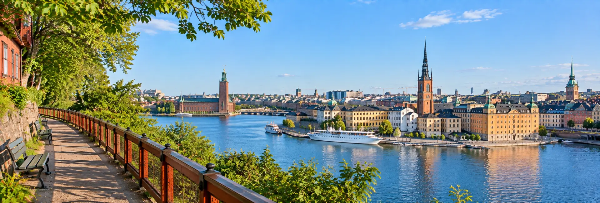
Monteliusvägen is a short cliffside walkway on the island of Södermalm that has become one of Stockholm's most reliable spots for a postcard view. Running for roughly 400 to 500 meters along the northern edge of Mariaberget, the path looks out across Riddarfjärden bay toward City Hall, Riddarholmen, and the rooftops of Gamla Stan.
It's a modest attraction in physical terms - a narrow pedestrian lane with benches and a handful of small parks - but the payoff is out of proportion to its size. Locals and visitors alike treat it as a place to slow down, particularly at sunset, making it as much a mood as a sight to check off a list.
History
From Rocky Cliffs to a Named Path
The path takes its name from Oscar Montelius, a Swedish archaeologist and member of the Swedish Academy who lived in the city until his death in 1921. Before the walkway existed in its current form, the area was part of the rugged, sparsely populated cliffs of Södermalm, historically home to fishermen and craftspeople rather than the sought-after residential district it is today.
A Path Delayed by Its Own Neighbors
Plans for a formal scenic walkway along these cliffs were first proposed in 1977, but local residents pushed back, worried about increased foot traffic so close to their homes. The proposal stalled for more than two decades before Monteliusvägen was finally completed and opened to the public in the late 1990s, as part of a broader effort to protect and showcase Södermalm's historic Mariaberget district.
The Walk & What to See
Monteliusvägen runs along the top of the Mariaberget cliffs, with wooden houses and cobbled lanes on one side and open views over the water on the other. The path begins near Bastugatan and continues toward Kattgränd, passing two small pocket parks, Ivar Los Park and Olle Adolphsons Park, that offer a quieter spot to sit away from the main viewpoints.
The main draw is the panorama itself: Stockholm City Hall directly across the water on Kungsholmen, the spires of Riddarholmen Church and Storkyrkan rising above Gamla Stan, and the wider expanse of Riddarfjärden reflecting the sky. Wooden benches line much of the route, many angled specifically to frame this skyline, making it easy to find a spot to simply sit rather than keep walking.
- Unobstructed views of City Hall, Riddarholmen, and Gamla Stan across Riddarfjärden
- Ivar Los Park and Olle Adolphsons Park, two small gardens accessible from the path
- Well-preserved 18th and 19th-century wooden houses lining the upper lanes
- Benches positioned along the route for extended views rather than a quick photo stop
Ways to Experience It
Monteliusvägen is designed to be walked slowly rather than rushed through, and most visitors treat it as a short, unhurried stroll rather than a hike. The full length can be covered in ten to fifteen minutes, though many people linger far longer on a bench taking in the view.
- Walking - the path itself is the main way to experience it, best done at an easy pace
- Photography - a popular stop for both amateur and serious photographers, particularly around sunset
- Pairing with a coffee - nearby cafes on Hornsgatan make it easy to bring a drink along for the walk
- Combining with other Södermalm viewpoints - Skinnarviksberget and Fjällgatan offer similar views nearby for those who want more than one vantage point
Best Time to Visit
Sunset is widely considered the best time to visit, when the light turns the water and rooftops golden and the City Hall skyline is silhouetted against the sky. Sunrise offers a quieter, similarly striking alternative for those willing to visit early, before the path's benches fill up.
The walkway is open and accessible year-round, with each season offering a different character: crisp reflections on the water in summer, autumn color along the cliffs, and snow-covered rooftops in winter. Winter visits do require some caution, since the city does not plow or salt the path, and the surface can become slippery.
Visitor Tips
Monteliusvägen is easy to reach but easy to miss if you don't know exactly where to look, since it isn't always marked clearly on maps and its entrance is tucked into a residential street. The path runs roughly parallel to Bastugatan and begins near Skolgränd, making that a useful landmark when navigating on foot.
- Wear sturdy, grippy footwear in winter, since the path is not cleared of snow or ice
- The path is unpaved and runs along an elevated cliff edge, which can be a challenge for visitors with mobility difficulties
- Arrive by early evening in summer if you want a bench to yourself around sunset, since the spot draws steady crowds
- The closest metro station is Slussen, a short walk from the eastern end of the path
- Dogs are welcome along the walkway, though it's courteous to keep them on a leash given the narrow path
Nearby Attractions
Monteliusvägen sits at the heart of Södermalm, within easy walking distance of several other well-known viewpoints and neighborhood landmarks.
- Skinnarviksberget - Stockholm's highest natural point, offering another panoramic outlook nearby
- Fjällgatan - a second, more heavily visited viewpoint on the eastern side of Södermalm
- Mariatorget - a lively square with cafes and shops, a short walk from the path
- Gamla Stan - Stockholm's historic Old Town, visible across the water and reachable via Slussen
FAQs about visiting Monteliusvägen
What is Monteliusvägen known for? +
It's a short cliffside walkway on Södermalm known for its panoramic views over Stockholm City Hall, Riddarholmen, Gamla Stan, and Lake Mälaren, especially at sunset.
How long is the walk? +
The path runs roughly 400 to 500 meters, which most visitors cover in ten to fifteen minutes, though many stay much longer to enjoy the view from a bench.
Is Monteliusvägen free to visit? +
Yes, it's a public pedestrian path with no admission fee.
When is the best time to visit? +
Sunset is the most popular time for the light and skyline views, though sunrise offers a similar experience with far fewer people.
Is Monteliusvägen accessible for visitors with mobility needs? +
It can be challenging, since the path is unpaved, narrow, and runs along an elevated, cliffside route without ramps.
How do I get to Monteliusvägen? +
The nearest metro station is Slussen, from which it's a short walk; the path itself runs roughly parallel to Bastugatan and begins near Skolgränd.
Is Monteliusvägen crowded? +
It can be, particularly around sunset in the warmer months, since it's a well-known and popular spot with both tourists and locals.
What else is nearby if I want more viewpoints? +
Skinnarviksberget, Stockholm's highest natural point, and Fjällgatan, another well-known Södermalm viewpoint, are both within easy walking distance.