Table of Contents
Overview
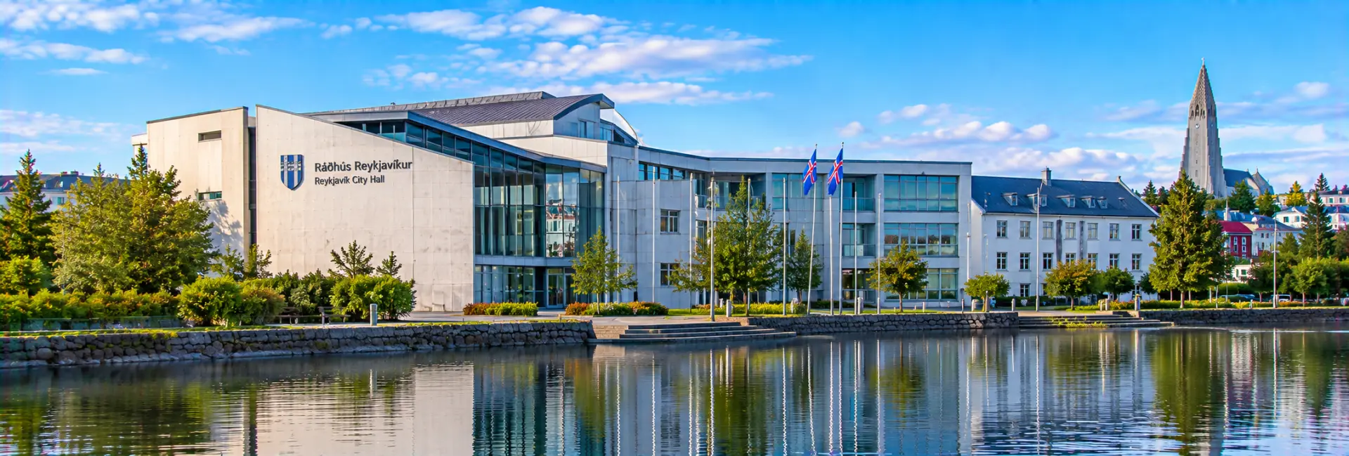
Reykjavík City Hall (Ráðhús Reykjavíkur) is the working headquarters of the city's government and, at the same time, one of the most approachable public buildings in Iceland's capital. It stands on the northern edge of the pond Tjörnin, in the historic center, where its concrete, metal and glass volumes reach out over the water. Opened in 1992, it was designed to feel like part of the surrounding landscape rather than a distant seat of authority.
Visitors come for two main reasons. The first is the building itself, an early and much-discussed example of contemporary Icelandic architecture, complete with a wall that grows moss. The second is the enormous relief map of Iceland displayed on the ground floor, which lets you look down on glaciers, highland plateaus, fjords and volcanoes in miniature.
The public areas can be entered without a ticket, and a stop usually takes well under an hour. That makes City Hall an easy, no-cost addition to a walk around Tjörnin, and a useful place to get your bearings on the country before setting out to see it.
History of the Building
A long-held idea
The wish for a proper city hall in Reykjavík is nearly as old as the town itself. For decades, municipal leaders weighed possible sites and invited design proposals, but a purpose-built home for the city's government took a long time to materialize. In the 1980s the plan was revived with a site beside Tjörnin, which was a sensitive choice because the pond is one of the most treasured spots in the city center.
The design competition
An international competition drew 38 proposals. In June 1987 the judges announced their decision, awarding first prize to two young architects, Margrét Harðardóttir and Steve Christer, who had both graduated from the Architectural Association School in London in 1984. Their practice, Studio Granda, was founded the same year the competition concluded.
Construction and opening
Construction began in 1988, and the building was inaugurated on 14 April 1992. Placing a modern civic building so close to the water prompted considerable public debate, and the structure has remained a topic of conversation ever since. Over the decades it has settled into the city's identity as a landmark that people use, cross and photograph, rather than simply pass.
Architecture & Design
A building between city and nature
Studio Granda described the building as an interface where the contrasts of nature and city intertwine in a complex, three-dimensional whole. Rather than presenting a grand stone facade, the architects let the building meet the pond directly, with parts of it extending out over the water so that it appears to float.
Materials and the moss wall
The exterior is a blend of gray concrete, metal and glass. One of the best-known details is the moss-covered wall near the junction of Vonarstræti and Tjarnargata, inspired by the mossy lava and rock walls found across Icelandic nature. Combined with a small, rounded pond at the corner, it brings the character of the countryside right into the middle of the city.
Open and democratic in spirit
The ground floor feels like an extension of the street. A public walkway passes through, and the largest function room, the Lake Room, is normally open to it. This is a deliberate choice: the design is meant to signal that a city hall is a place for residents rather than a closed, ceremonial fortress.
Two connected sections
The building consists of connected sections that combine municipal offices with public spaces. Studio Granda's wider work is known for its respect for local materials such as stone, sheet metal and timber, and this early project is often seen as a key step in that approach.
The Relief Map of Iceland
A country in miniature
The star attraction inside is a large three-dimensional model of Iceland in the Lake Room. It has been on permanent display in the western part of the room since the building opened in 1992. Walking around its edges, you can trace the shape of the island's coastline, the central highlands, the ice caps and the long, finger-like fjords of the northwest.
How it was made
The model is built from cardboard only one millimeter thick, with each layer cut out along the contour lines of the survey maps and stacked to form the terrain. One travel guide reports that four craftsmen spent about four years building it.
Size and scale
- Horizontal scale: 1:50,000
- Height exaggerated to twice that, giving a vertical scale of 1:25,000
- Total area: about 76.4 square meters, measuring roughly 7.2 by 10.6 meters
- Built in 57 sections
Why it is worth a look
The exaggerated heights make volcanoes, mountain ranges and glacier tongues stand out clearly, so the map doubles as a quick lesson in Icelandic geography. It is particularly useful before a road trip, because you can see how far apart regions really are and where the empty interior sits.
What to See Inside
The Lake Room
Tjarnarsalur, the Lake Room, is the largest function space in the building and is used for meetings, receptions and exhibitions. Unless an event is under way, visitors can walk freely through it and examine the relief map. Large windows face the pond, so you can pair the map with a view of the pond and the birds on it.
Changing exhibitions and events
The building is sometimes used for art exhibitions, civic functions and live music, so what you see inside varies from visit to visit. Check the city's website for what is scheduled.
Visitor services
Over the years the ground floor has also housed visitor information and a small café. Availability of these services has changed from time to time, so confirm what is open if you are counting on them. Public restrooms have been reported to be available during opening hours.
Pond views from the outside
Do not skip the exterior. The edge of the building meets the water, and the surrounding paths offer good angles for photographs across the pond.
Ways to Experience It
As a short stop
Most visitors drop in for 20 to 45 minutes, long enough to circle the relief map, glance at any exhibition and look out over the water. Because entry is free, it fits easily into a larger sightseeing day.
As part of a Tjörnin walk
A lap around the pond takes in the City Hall, the old residential streets and a number of civic and cultural buildings. The bird life is a draw in itself, with waterfowl and swans on the water.
As an introduction to the country
If you are early in your trip, the map helps with planning. Use it to match names from your itinerary to actual places, and to understand why routes between regions are so long.
For architecture fans
Studio Granda also designed other well-known buildings in Reykjavík, so City Hall pairs well with a wider look at modern Icelandic architecture. Looking at the way it meets the water, the moss wall and the open ground floor gives a good idea of the architects' intentions.
Best Time to Visit
Weather and season
City Hall is open year-round, and most of what there is to see is indoors, which makes it a good choice on wet or windy days and in winter. In summer, the surrounding pond is at its liveliest, with long evenings and a steady stream of walkers.
Time of day
The space is modest in size and the map is easy to view at most times of day. Late afternoon light can be attractive on the glass and water outside, but check opening hours first.
Opening hours
The city lists City Hall as open on weekdays from 8:00 to 18:00, on Saturdays from 10:00 to 18:00 and on Sundays from 12:00 to 18:00. The Lake Room can be closed for private events, and hours can change on holidays, so check the city's website for the day you plan to visit.
Visitor Tips
The visit is simple, but a few details help:
- Entry to the public ground-floor areas is free during opening hours.
- The relief map is not available when the Lake Room is reserved for an event, so check the city's list of closure dates if the map is the main reason for your visit.
- Walk all the way around the map; the highland interior and the Westfjords look quite different from different sides.
- Use the map to plan routes, since the exaggerated heights make mountain barriers easy to spot.
- Combine the visit with a loop of the pond; it adds little time and gives context to the building's setting.
- Do not count on a café being open; there are plenty of places to eat within a short walk.
- Remember that this is a working government building, and be considerate near offices and meeting rooms.
Nearby Attractions
City Hall sits in the middle of the old town, so most of the city's major sights are only a short stroll away.
- Tjörnin: the pond right outside, with walking paths and plenty of birdlife.
- Austurvöllur and the Parliament House: the historic square and seat of Iceland's parliament, a few minutes' walk to the north.
- Reykjavík Cathedral: the city's main Lutheran church, next to Austurvöllur.
- National Gallery of Iceland: the art museum on the eastern shore of the pond, at Fríkirkjuvegur 7.
- Iðnó: the historic theater and cultural venue on the pond's edge.
- The Settlement Exhibition: the underground museum around a Viking-age longhouse on Aðalstræti, close enough to combine on foot.
FAQs about visiting Reykjavík City Hall
What is Reykjavík City Hall known for? +
It is known for its modern lakeside architecture, including a moss-covered wall, and for a large three-dimensional relief map of Iceland on display in the Lake Room.
Is Reykjavík City Hall free to visit? +
Yes. The public areas on the ground floor, including the relief map, can be visited without a ticket during opening hours.
When is City Hall open? +
The city lists weekday hours of 8:00 to 18:00, Saturdays from 10:00 to 18:00 and Sundays from 12:00 to 18:00. Holidays and private events can change this, so check the city's website before you go.
Where is the relief map of Iceland? +
It is in Tjarnarsalur, the Lake Room, on the ground floor. It has been on permanent display there since the building opened in 1992, except when the room is booked for events.
How big is the Iceland map? +
It covers about 76 square meters and is built at a horizontal scale of 1:50,000 with heights exaggerated twofold. It is divided into 57 sections.
How much time do I need? +
Around 20 to 45 minutes is typical. Allow more if you want to walk around Tjörnin as well.
Who designed Reykjavík City Hall? +
The architecture practice Studio Granda, led by Margrét Harðardóttir and Steve Christer, won the international design competition in 1987. The building opened in 1992.
Can I buy food or coffee inside? +
A café and visitor services have operated in the building at different times, but availability can change, so do not rely on it. Many cafés and restaurants are within a short walk in the old town.